


SUÐUROY | A WILD UNTOUCHED WILDERNESS, HIKER'S HAVEN AND HIDDEN GEM OFF THE BEATEN PATH
Link Copied!

9 October 2023 | Written by Hannah Verman of Finding Our Adventure
Note: All images are subject to the copyright of ©Finding Our Adventure
The wild untamed island of Suðuroy lies at the most southern point of the Faroe Islands archipelago. For those seeking an exhilarating adventure off the beaten path, the remote island of Suðuroy is the answer. This island is a hidden gem of the Faroe Islands, a rugged and windy landscape overflowing with wild beauty and incredible hiking trails waiting to be discovered.
Uncover the untouched wilderness of Suðuroy, whilst driving epic winding roads and witness the relentless wind that creates the phenomenon of reverse waterfalls at Ásmundarstakkur or Skúvanes. The eastern side of Suðuroy is populated by villages, due to its more accessible landscape whereas, the western side of the island is dominated by huge cliffs and mountains.
Suðuroy has some of the most scenic roads, guiding explorers through tunnels and across mountain passes where you will be spoiled with breathtaking views from above. This pocket-sized guide will share the best places to visit on Suðuroy, including hikes, scenic drives and charming villages, without forgetting warm Faroese hospitality.


The adventure of getting to Suðuroy
As the most southern island of the Faroe Islands, it is the furthest to travel to once you land at Vágar Airport. If you’re visiting the Faroe Islands for a 5-7 days minimum, then a trip to Suðuroy will be worthwhile as the journey to the island takes over 2 hours on the ferry which is all part of the adventure.
The island is not suitable for a day trip from Tórshavn as the total journey time on the ferry and back will be around 5 hours and leaves little time to explore Suðuroy. There is the option to get a helicopter from Tórshavn to Froðba which takes 30 minutes, this is only possible one way as it is not designed to take tourists on a round trip and is mostly used by locals, which means you would have to return by ferry.
The ferry leaves from Tórshavn at Farstød terminal where you must arrive at least 30 minutes before departure. Payment for the ferry is made on the return journey on deck and there is no need to reserve your place onboard.
The journey to Suðuroy will take you past many islands, including Sandoy, Stora Dimun and Litla Dimun with only sheep as residents and is the smallest of all the islands. Sit on the right-hand side of the ferry for great views of the other islands en route and if the weather is good head out onto the deck!
The best thing to do when visiting Suðuroy is to stay on the island for a night or two to uncover the best locations and have enough time to go hiking if the weather conditions allow!

Explore southern Suðuroy
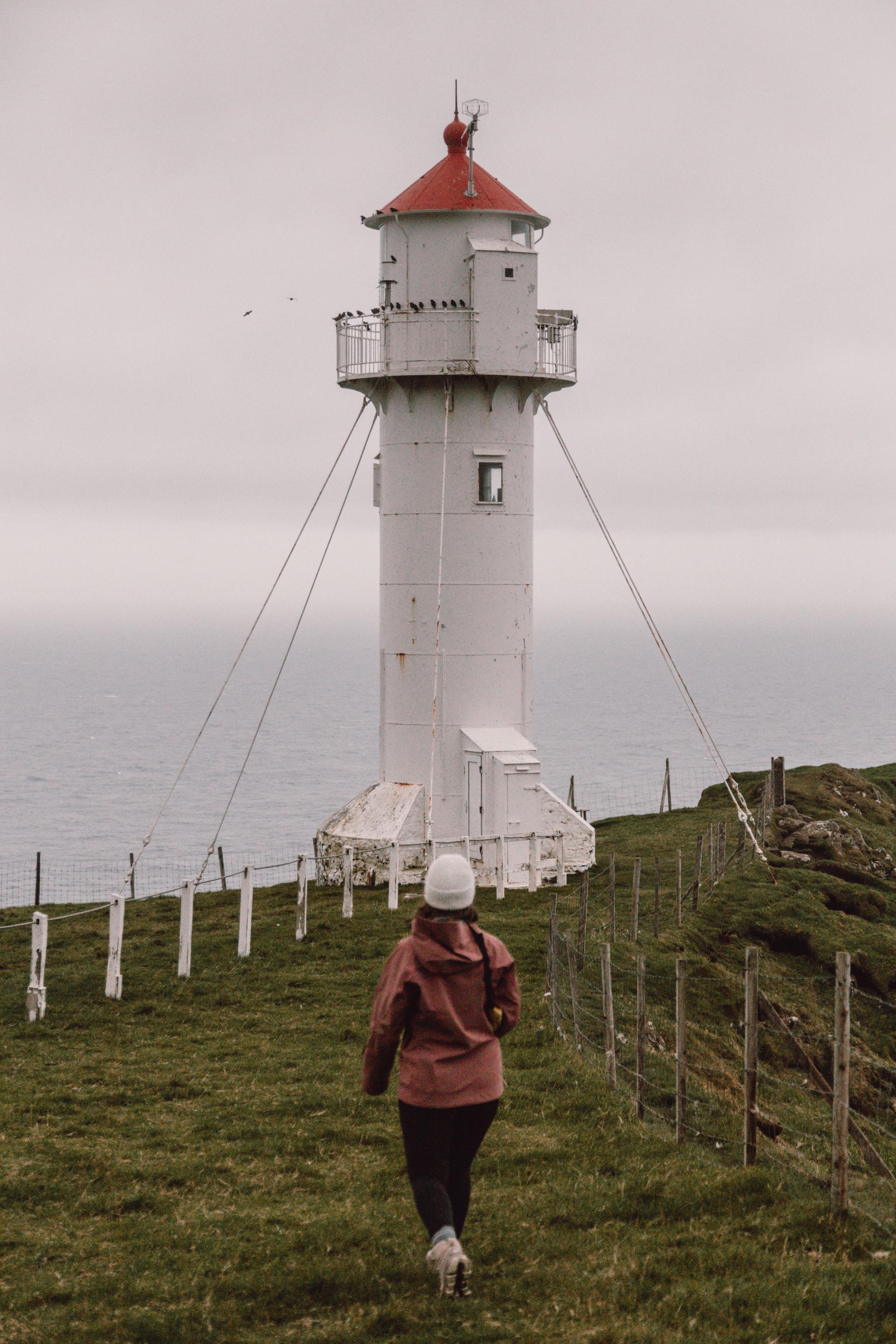
Once you arrive on the island of Suðuroy, head to the southernmost point of the Faroe Islands, Akraberg Lighthouse. The lighthouse stands on the edge of tall cliffs, it’s crazy to think of how many storms this lighthouse has endured since its construction in 1909 and it is supported by strong metal cables. Take care when walking around this area as sudden gusts of wind can cause you to lose your footing and the grass can make it unstable and slippery, especially when wet.
The next stop is Sumba, the southernmost village of the Faroe Islands a tunnel built in 1997 now connects the village to the rest of the island throughout the year whereas the village was only accessible via a mountain pass during good weather conditions.
In good weather, take the old road known as “Um Hestin” from Sumba back to Lopra, a single-lane mountain pass which is not accessible in snowy conditions. This is one of the two Buttercup routes on Suðuroy, Buttercup routes are designated scenic driving routes across the Faroe Islands.
Following the mountain pass will take you past the spectacular sea cliff of Beinisvørð, the highest cliff on Suðuroy, where historically the village of Sumba would hunt for sea birds and eggs as a source of food. These cliffs are very exposed and be careful not to walk close to the edge as many birds burrow beneath the soil and can collapse from the weight above.


Discover the heart of Suðuroy
There are plenty of hikes to choose from on the island including a short 20-minute hike from Lopra village to Lopranseiði which reveals beautiful views overlooking the west coast of Suðuroy. Vágur is a great place to base yourself for your stay on Suðuroy and BRIM B&B is a cosy family-run B&B with beautifully decorated rooms.
Explore the nearby cliffs at Eggjarnar, accessible by a steep unpaved road to a small place to park your car and admire the incredible coastal views. There is also the option to hike from the Eggjarnar viewpoint to the Rávan summit. From Vágar, you can either walk or drive to Vágseiði panoramic viewpoint and here you will hear the roar of the Atlantic Ocean crash against the cliffs.
Vágur village has its very own Art Museum with a collection of one of the most famous painters from the Faroe Islands, Ruth Smith who was influenced by Cezanne. Take a trip on a 19th-century Schooner, Johanna TG326 which is docked in the harbour at Vágur to see a different perspective of Suðuroy from the ocean.
The second Buttercup route is “Um Hovsegg” and starts in Hov and Øravík, there are basalt column rock formations found along this route. Make sure to stop by Vatnsnes Lake, a serene and peaceful place surrounded by spectacular scenery and there is even an Airbnb you can book to stay the night.
Fámjin is a remote village on the west coast of Suðuroy, surrounded by the highest mountains on the island and also home to a white church built in 1876 which has the first-ever Faroese flag on display.


Wander the north of Suðuroy
One of the most famous hikes on Suðuroy is to Hvannavatn Lake and the valley of Hvannhagi from Tvøroyri, where you’ll observe some of the best views on the island. The hike starts from the hospital in Tvøroyri, passing through woodland and along a track until you reach a signpost where you will follow orange markers along the route leading you to the lake.
The hike to Hvannhagi will take 3 hours in total and is best in good weather conditions otherwise it can be challenging to navigate especially in heavy fog. The route is rated as medium difficulty with steep and narrow sections unsuitable for children. There is a circular route but it is not recommended without a guide and we would recommend taking the one-way route. The best thing after completing the hike is to cosy up in Café MorMor, a quirky café serving some delicious homemade soups, coffee and cakes.
The village of Hvalba is the only place in the Faroe Islands to produce coal which is still in use today to supply locals, it is possible to take a tour around the active coal mine to learn about the history and process. Take the small mountain tunnel from Hvalba to Sandvík, the most northern village on Suðuroy which has a spectacular black sand beach.
Take the road west of Sandvík, there is a spot to park your car and hike to the impressive Ásmundarstakkur sea stack on the west coast of the island and is a great sunset spot which only takes 30 minutes from the track. There is also a very exposed bridge further south along the coast, this is best accessed with a guide for safety.
Make sure to check out more insightful guides about the Faroe Islands by Jonny and Hannah on Finding Our Adventure.
Uncovering a different side to the Faroe Islands

Tórshavn marathon

The food culture of the Faroe Islands

The Faroe Islands... through the eyes of a New Yorker

Fog with a chance of hihing in the Faroe Islands

G! festival: cue the music for nature lovers

Sheep farming in the Faroe Islands

Discovering the Faroe Islands by bicycle

Best things to do in the Faroe Islands

